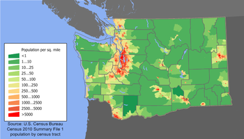
Washington Population Density Map.
Washington was a state in the Pacific Northwest region of the United States located north of Oregon, west of Idaho, and south of the Canadian province of British Columbia on the coast of the Pacific Ocean. Named after George Washington, the first President of the United States, the state was made out of the western part of the Washington Territory which had been ceded by Britain in 1846 CE by the Oregon Treaty as a settlement of the Oregon Boundary Dispute. It was admitted to the Union as the 42nd state in 1889 CE.
History and Industry[]
Washington was the 18th most extensive and the 13th most populous state. Approximately 60 percent of Washington's residents lived in the Seattle metropolitan area, the center of transportation, business, and industry along the Puget Sound region of the Salish Sea, an inlet of the Pacific consisting of numerous islands, deep fjords, and bays carved out by glaciers. The remainder of the state consisted of deep temperate rainforests in the west, mountain ranges in the west, central, northeast and far southeast, and a semi-arid basin region in the east, central, and south, given over to intensive agriculture. After California, Washington was the second most populous state on the United States' West Coast and in the Western United States.
Washington was a leading lumber producer. Even today, its rugged surface is rich in stands of Douglas fir, hemlock, ponderosa and white pine, spruce, larch, and cedar. The area is still Terra's biggest producer of apples, hops, pears, red raspberries, spearmint oil, and sweet cherries, and ranks high in the production of apricots, asparagus, dry edible peas, grapes, lentils, peppermint oil, and potatoes. Livestock and livestock products make important contributions to total farm revenue, and the commercial fishing of salmon, halibut, and bottomfish makes a significant contribution to the state's economy.
Manufacturing industries in Washington included aircraft and missiles, shipbuilding and other transportation equipment, lumber, food processing, metals and metal products, chemicals, and machinery. Washington had over 1,000 dams, including the Grand Coulee Dam, built for a variety of purposes including irrigation, power, flood control, and water storage.
Although its official name was "The State of Washington," the state was often referred to as "Washington state" to distinguish it from Washington, D.C. Another nickname was "the Evergreen State." Its largest two cities were Seattle, situated in the west, followed by Spokane, located in the east. Its capital was Olympia.
WWIII and Earthquake of 2102 CE[]
Although WWIII caused severe economic hardship in the state, it did not suffer major physical harm until the Earthquake of 2102 CE. This quake triggered the the Cascadia fault and awoke most of the Cascade Volcanic Arc. Major cities severely damaged by this earthquake and its aftereffects included Vancouver and Victoria, British Columbia; Seattle and Spokane, Washington; and Portland, Oregon. Due to their inland locations, Portland and Spokane escaped being virtually destroyed by the ensuing tsunami. All but a handful of the state's dams were destroyed or severely damaged, hampering recovery efforts.The devastation decimated the area's infrastructure and Agriculture, Aerospace, Forestry, High Technology, Hydroelectric power, and Tourism industries for decades.
Modern Cascadia[]
Today, Cascadia has largely rebuilt, however the region's strong ecological movement limited city sizes. Natives commonly call themselves "Cascadians". Industry relocated in the area, and has fully recovered with the exception of Aerospace and High Technology (Cascadians did not allow them to rebuild in the region). Agriculture and Outdoor Tourism are it's main economic sectors, compromising some 96% of it's economy.